
Identification of the critical environmental issues for the Lazio Region - SRSvS
Goals
The main goal of the “Specialist support service for the definition of the contribution of climate change adaptation to the Regional Strategy for Sustainable Development (SRSvS)“ promoted by the Lazio Region is to support the integration of climate change issues in regional policies, plans and programs through the identification of guidelines and lines of action for the implementation of SRSvS.
Carried out activities
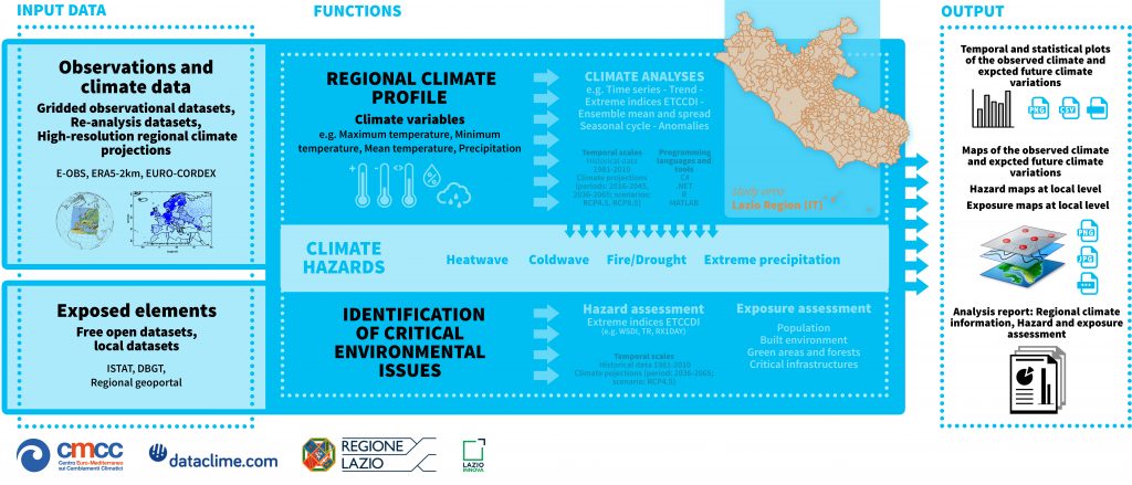
The study developed the regional climate profile and identified hazard, exposure and vulnerability. This has allowed to identify the main critical environmental issues and the adaptation goals for the Lazio Region. The study assess:
- the main hazards affecting the Lazio Region and related exposed assets (population, built environment, green areas and forests, critical infrastructures) with a quantitative approach;
- the vulnerability, regarded as “the ability to evaluate risks” of local institutions which are responsible for the safety and well-being of the population and public assets, with a qualitative approach.
The methodology adopted follows the approach included in the 5th Assessment Report of the Intergovernmental Panel on Climate Change (IPCC) for the assessment of climate-related risks.
The study was carried out by the Foundation Euro-Mediterranean Center on Climate Change (CMCC) that provide the simulation of climate scenarios, the quantification of hazard and the analysis of exposure and vulnerability.
Dataclime functionalities
- Regional climate profile: analyses of current climate conditions (reference period) and future (IPCC scenarios and high-resolution models) through the calculation of several climate indices* (about 70) which are identified both from literature and in relation to local needs.
- Identification of critical environmental issues: elaboration of hazard maps at local level based on the analyses included in the climate framework, and integration with exposed elements. The exposure maps, provided at local level, can be selected according to the thematic area of interest related to the exposed element and the associated climate hazard (e.g. population and heatwave, built environment and heatwave, critical infrastructures and extreme precipitation).
Note:
*The climate indices are synthetic parameters which are obtained from several atmospheric variables (e.g. temperature, precipitation) aimed at analyzing the main characteristics of extreme climate events and their potential variations in the future. Climate indices mainly describes the magnitude and frequency of extreme climate events related to precipitation and temperature, and are often adopted in sectoral studies aimed at assessing the main climate impacts at local level to develop adaptation strategies.
Link: